1 Introduction
In 1934, T. S. Eliot posed a profound question in his work “The Rock,” which still holds significance today: “Where is the wisdom we have lost in knowledge? Where is the knowledge we have lost in information?” These words cast a critical light on the challenge of preserving knowledge in a society characterized by information overload. Although Eliot formulated his thoughts from a more spiritual perspective of the early 20th century, his question finds remarkable resonance in modern times, particularly in the engineering industry, which often faces the challenge of extracting usable knowledge from a wealth of collected information. Without adequate capture, structuring, maintenance and provision of planning information collected over time, there is a risk that essential project knowledge is lost.
Building Information Modeling (BIM) has established itself as a widely proven and established method for efficient collaboration, especially in the field of high-rise and infrastructure construction, where it is now considered standard. BIM is a process-oriented approach that involves the creation and management of digital representations of the physical and functional characteristics of a construction project. It enables the involved actors to access a common data base through the use of digital models, thereby making the planning, construction and management of buildings and infrastructures more efficient and transparent. (1)
Against this backdrop, the question arises as to how an equivalent approach like BIM could be applied in mining. Mining, and here in particular the construction of repositories for radioactive waste, with its unique challenges and requirements, represents a complex field that could benefit from the digital and integrative capabilities of BIM. Exploring the applicability and adaptation of BIM in these sectors offers an exciting opportunity to significantly improve efficiency and safety in these critical and often undervalued industries.
To illustrate the advantages and potentials of BIM in these areas, the example of the Konrad shaft repository for radioactive waste of BGE Bundesgesellschaft für Endlagerung mbH (BGE), Peine/Germany, in Salzgitter will be used. A detailed examination of this project is intended to show how BIM supports the planning, construction, and coordination of complex construction projects in mining and repository construction.
2 Current state of BIM in nuclear waste repository construction and/or mining
The number of repositories for nuclear waste is limited, as are the examples of the use of BIM in their planning, not to mention a standardization of data processing processes. Despite these challenges, there are remarkable developments, particularly in Finland. An article on the “Nuclear Engineering International” website from 2016 highlights the growing importance of BIM in the international nuclear sector, specifically in the context of repositories. A prominent example of the use of BIM is the Final Disposal project developed by Posiva1 in Finland, the world’s first of its kind for the final storage of spent fuel rods.
- 1
This project employs BIM for the planning and design of both the above-ground structures and the underground access tunnels and storage passages. BIM is crucial for the integration and optimization of extensive data volumes in a digital model. The benefits include the reduction of the need for remodelling, increased process transparency and support in cost calculation, e. g. through the possibility of quantity evaluation. Furthermore, all underground rock surfaces are recorded using laser scanning and integrated into the BIM models, significantly supporting quality control, communication and visualization during project execution. In addition, BIM enables the use of Virtual Reality (VR) and Augmented Reality (AR) to visualize the project results. (2)
The publication “Tunnelling & Mining Information Modelling; a Digital Environment for Next Generation Mining” (3) by Jyrki Salmi, PhD student and Research Director in the field of digitalization and automation of mining at the University of Oulu/Finland, discusses the application of BIM in mining and tunnel construction.
The article is based on workshops at the University of Oulu as part of the “Next Generation Mining” project, with over 100 participants from over 50 companies. The focus is on the challenges and potentials of the BIM method in underground mining, which has so far been primarily used in above-ground projects. The authors emphasize the need for effective information management in mining to increase productivity and improve project quality. Advantages of BIM in mining include improved collaboration, automation, advanced analysis and more efficient information management. In summary, the article highlights the interest and willingness of the Finnish mining and tunnel construction sector to further develop BIM and outlines future research and development directions in this area.
The current state of the use of BIM in the field of repositories for radioactive waste and in mining shows that the application of this technology is still in its infancy, although it offers significant advantages. Despite limited examples of BIM applications, particularly in Finland, the use of BIM in these sectors is not yet widespread. BIM has the potential to significantly improve the planning and construction of repositories and mining projects. Through the integration and optimization of extensive data volumes in a digital model, BIM can contribute to more efficient planning, increased transparency, and better cost control.
3 Successful application of BIM: the case of the Konrad shaft repository
In the following, the application of the BIM method at the Konrad shaft repository is exemplarily presented. The Konrad Shaft facility is currently the site where the first nuclear law-approved repository for low- and medium-level solidified radioactive waste with negligible heat development is being created in Germany. Originally, the Konrad shaft was an iron ore mine, and its conversion into a repository was a lengthy process. It is planned to store 303,000 m3 of packaged low- and medium-level radioactive waste. The approval of the repository was granted through an extensive nuclear licensing procedure, which took about 20 years. In addition to the BGE, other actors such as licensing and supervisory authorities, as well as the public, are involved in the construction of the Konrad shaft repository.
Large infrastructure projects are typically lengthy undertakings that often lack flexibility to keep pace with rapid technological developments, especially in the area of planning tools. The Konrad shaft repository project represents a remarkable exception in this regard. Despite the known challenges of integrating BIM into an ongoing project, the BGE decided to implement this advanced method to coordinate the entire underground control area. To realize the benefits of BIM promptly, the project team initially focused on the most fundamental yet promising use cases of BIM. This targeted approach enabled rapid improvements in planning coordination. Key applications include:
- Coordination of various specialized trades: BIM enables more efficient and precise coordination between different construction trades.
- Visualizations: BIM facilitates the creation of detailed and realistic visualizations of the project, leading to improved understanding and more efficient planning processes.
- 4D Simulation: This allows for the simulation and optimization of the project’s timeline, thereby identifying and avoiding potential issues early on.
- Use of VR and AR: These technologies enhance spatial understanding and offer innovative ways to interact with and within the project.
The approaches described below were chosen to fulfill these use cases.
3.1 Model coordination
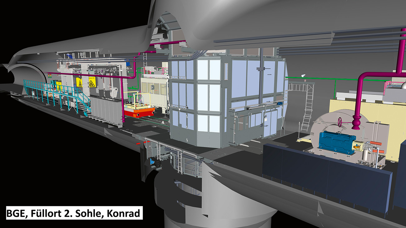
Fig. 1. Section through the coordination model in the BIM model viewer. // Bild 1. Schnitt durch das Koordinationsmodell im BIM-Modellviewer. Source/Quelle: CDM Smith
The project team faced the challenge in model coordination that only a portion of the plans existed in 3D. As a fundamental step, all necessary models were first converted into a 3D format to enable spatial coordination (Figure 1). The existing 3D models, for which there were no uniform guidelines, varied greatly in structure and level of detail. Particularly challenging was the model detailing, as many models originated from the field of plant construction and were modeled down to the smallest components such as washers and screws. These models had to be simplified and converted into compatible formats to enable effective coordination – the spatial alignment of the models to each other – as well as collision checks.
A central and extremely helpful tool in this process was the introduction of a Common Data Environment (CDE). Within the CDE, models and the coordination model could be made accessible to all participants. This significantly simplified and accelerated the identification and management of collisions as well as required adjustments. Task management within the CDE played a key role by enabling efficient communication and coordination between the various teams.
3.2 Visualizations
Visualizations play a crucial role in understanding and communicating complex projects, especially in the context of public participation. They make it possible to vividly depict spatial conditions and visualize processes during the construction phase and operation. In this project, the team used the coordination model and converted it for different applications. This included creating video sequences with textured models and rendering images of specific areas (Figure 2).

Fig. 2. Rendering of the BIM coordination model. // Bild 2. Rendering des BIM-Koordinationsmodells. Source/Quelle: CDM Smith
The current market offers a variety of software options for generating such videos and images. These tools are not only technically advanced but also user-friendly, allowing the team to quickly create high-quality visual content. These visual representations are invaluable for communicating with stakeholders, as they make it possible to convey complex technical details to a non-technical audience. By using visualizations, the project team can effectively and vividly convey how the project will be realized and its impacts, thus ensuring transparency and building trust with the public.
3.3 4D Simulations
Construction process simulations, known as 4D simulations, represent an innovative method to visualize the construction process. They link the schedule directly with the model elements and depict this connection in a simulation video. This makes the construction process more understandable and comprehensible to people. A key advantage of this technique is that it allows for a better understanding of the individual construction phases and simultaneously helps to identify potential collisions or conflicts in the schedule and construction and assembly processes that would remain hidden in traditional waterfall diagrams.
The applications of 4D simulations are diverse. They can be used for both the representation of the entire project course and for smaller sequences, such as the construction of complex components. The simulations offer various viewing options. They can be consumed as a video, which allows for a simple and quick overview. In addition, Mixed Reality (MR) and VR technologies offer the possibility to interactively immerse in the simulation. Users can pause, rewind the simulation, and change the perspective at will, to gain a deeper understanding of the construction processes.
This interactive component significantly expands the range of application possibilities of 4D simulations. It allows participants to virtually move through the various construction phases, thus developing an intuitive and comprehensive understanding of project progress and the associated challenges.
3.4 Use of VR and AR
The use of VR and AR in construction projects represents a revolutionary development in the viewing and interaction of planning and coordination models. VR allows participants to move in a completely digital environment, making the project experienceable in a virtual world, almost as if they were physically on site. The team used this technology to gain a better understanding of dimensions, as well as to walk through the model together to discuss changes and adjustments. The team could meet virtually in a model, regardless of their physical location. The technology could be described as a kind of virtual site inspection of the yet unbuilt object.
AR, on the other hand, offers the possibility to overlay digital information in the real world as a hologram. This technology is particularly intended underground, to display planning models at the intended location. This technique allows for a better understanding of the future facility by integrating planning data directly into the context of the physical location.
The use of model-based collaboration and the use of advanced technologies have noticeably improved communication and efficiency in collaboration. Model coordination revealed numerous previously hidden collisions in 2D plans. In addition, the BIM models serve as an effective communication medium, allowing participants to communicate at the respective planning location, with everyone having the same views. This minimizes the risk of interpretation misunderstandings. Clear communication and structured handling of data and models enable the team and all those involved in the planning to carry out the project efficiently and transparently. This is essential for the realization of a large and important infrastructure project.
4 Outlook
In the framework of the presented project example, fundamental BIM use cases were selected for implementation. However, it should be emphasized that based on a well-structured coordination model, further application possibilities are feasible. The following list provides an overview of possible use cases that could be of considerable benefit in the construction of a repository:
- Virtual commissioning: This process involves integrating BIM models with control systems of programmable logic controllers (PLC). The main function is to link the models with real control programs and conduct a virtual simulation of operations. This allows for the identification and correction of potential issues, such as collisions or malfunctions, before the actual commissioning. This approach can minimize risks and improve the safety and efficiency of operations.
- Operation and maintenance with SAP interface: Expanding the BIM models with specific attributes and functionalities enables seamless integration with enterprise resource planning systems (ERP) like SAP™. This approach facilitates the management of maintenance logs, spare parts orders and other operational processes. By directly connecting the physical structure with its digital twin, maintenance activities can be planned and executed more efficiently, maximizing operating time and reducing costs.
- Virtual training for health and safety: The use of BIM technology for employee training focuses on simulating realistic work environments and scenarios. This can include emergency responses, routine maintenance procedures, or even specific approaches to unusual operating conditions. Training in a virtual environment allows employees to safely confront various scenarios, not only improving their skills but also contributing to overall workplace safety. This is particularly invaluable in high-risk environments like repositories for radioactive waste.
In summary, it can be said that the application of the BIM method offers enormous potential to optimize planning and execution processes in mining and the construction of repositories. Although there are currently no specific standards like in high-rise construction, the application of BIM methods in mining and repository construction is certainly possible and can contribute to significant efficiency improvements.
References / Quellenverzeichnis
References / Quellenverzeichnis
(1) Was ist BIM? Digitales Planen einfach erklärt. www.autodesk.com/de/design-make/articles/was-ist-bim. Zuletzt abgerufen am 29.12.2023.
(2) Engaging with BIM – Nuclear Engineering International. www.neimagazine.com/features/featureengaging-with-bim-5672206/. Zuletzt abgerufen am 21.12.2023.
(3) Salmi, J.; Heikkilä, R.; Hyytinen, M. (Hg.) (2023): Tunnelling & Mining Information Modelling; a Digital Environment for Next Generation Mining.
(4) Bundesgesellschaft für Endlagerung. www.bge.de/de. Zuletzt abgerufen am 29.12.2023.