When a coalfield finally ceases production there will no longer be any operational requirement to continue with the mine pumping and dewatering operations. Switching off the pumps generally results in an increase in mine-water levels. This process can take place very quickly or may even last several years or decades. Rising mine-water levels are an ongoing event in many places, not only in Germany but around the world, and the public is sometimes completely unaware that they are happening. In the former mining area of South Butterknowle in the Durham coalfield (United Kingdom) an inaccurate assessment of the hydrogeological conditions resulted in mine water and groundwater being mixed together. This paper will seek to show how lessons can be drawn from the Durham experience and how the mine-water management procedures adopted during the post-mining phase in the East of Wear (UK) and Lorraine (France) mining areas can be adapted with a view to providing long-term protection for the aquifers in these regions.
1 Introduction
The permanent closure of the German coal industry at the end of 2018 created an increasing need to tackle the challenges of the post-mining era and to manage the related problems in a sustainable way. In this context it is expedient to look back at the experiences associated with the closure of other coalfields both in Germany and elsewhere. The Research Institute of Post-Mining, which is attached to the TH Georg Agricola University in Bochum/Germany, carries out systematic analyses of international experience in this area and assesses the options available for transferring this know-how to the Ruhr, Saar and Ibbenbüren coalfields. Much of this work has focused on the experiences of the United Kingdom, whose many individual coalfield areas have now all been closed. The organisational structure and development of mining operations in the United Kingdom, and in the Yorkshire coalfield in particular, have already featured in a number of reports (1, 2).
2 Durham coalfield/UK
The Durham mining area lies to the south of the Northumberland coalfield on the north-east coast of England. At the beginning of the 20th century Durham was producing nearly 42 Mt of coal (3) and was one of the country’s most important coal mining regions. The coalfield was divided into several smaller working districts and the following paper will focus on the South Butterknowle and East of Wear areas, which lie adjacent to each other and are hydraulically segregated by the Butterknowle fault (Figure 1).
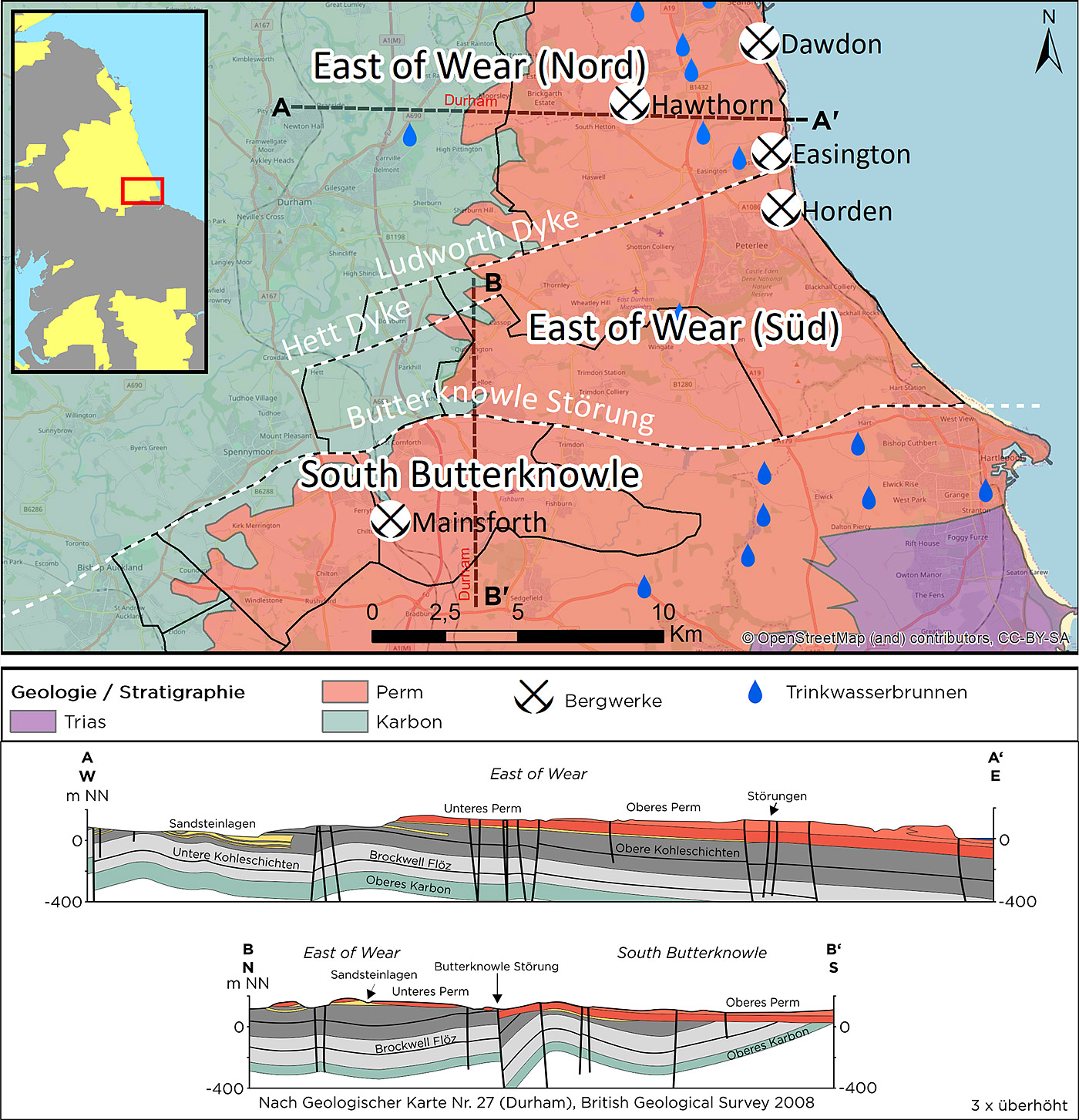
Fig. 1. Position and geology of the East of Wear and South Butterknowle working districts of the Durham coalfield (United Kingdom). Wells used for the supply of drinking water are shown as blue droplets. Geology colours as recommended by the International Stratigraphy Commission. Geological data provided by the British Geological Survey, mining areas according to (9).
Permian limestone beds form the regional joint aquifer (Permian Magnesian Limestone), which is of huge water-resource significance for the North East of England (4). With an average total of about 36,000 m3 (equivalent to some 25 m3/min or 13 Mm3/a) of water being extracted each day by Northumbrian Water Ltd. this resource meets the water supply needs of approximately 150,000 people living in and around the Durham area (5). It is also an important source of water for local agricultural and industrial consumers (6). The lithology mainly comprises magnesium-rich limestones, dolomite, marl and interposed evaporite beds. The aquifer is underlain by Carboniferous deposits that have already been extensively mined. Coal extraction was continued below the North Sea following the eastwards dip of the strata (profile section A-A’ in Figure 1). The last of the Durham mines were closed in the early 1990s. The cessation of much of the mine dewatering work has caused mine-water levels to rise over a wide area.
2.1 South Butterknowle mining district
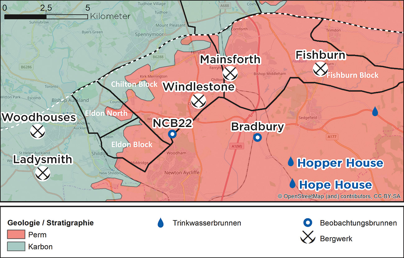
Fig. 2. South Butterknowle region of the Durham coalfield. The black lines indicate the limits of the different mining blocks (according to (9, 11)). The entire area was closed down, and subsequently flooded, during the 1970s. This flooding operation resulted in some local impairment of the overlying Magnesian Limestone aquifer, as verified at observation well NCB22 (7, 8, 9).
The first case in the United Kingdom of aquifer contamination by rising mine water was documented in the southern part of the Durham coalfield south of the major Butterknowle fault (Figure 2) (7, 8, 9). In this area much of the Carboniferous lies discordantly below the limestone beds of the Magnesian Limestone aquifer (section B-B’ in Figure 1), from which it is only hydraulically separated at local level by a layer of marl.
Even when flooding operations commenced in the early to mid 1970s there was an awareness of the problem that rising mine water could enter the aquifer and cause contamination. The general absence of a marl barrier meant that even when the mines were in operation large quantities of water flooded into the pits from the Magnesian Limestone – at Mainsforth this amounted to as much as 20,000 m3/d or 13.6 m3/min (10) – a situation that required an extremely efficient dewatering system. It was therefore clear that significant hydraulic pathways had to be present between the deposits and the overburden rock, these taking the form of joints and fissures. This situation was the result of mining-induced ground movements and the associated fracturing of the overlying rock (10).
The first phase of the flooding at Mainsforth mine (Figure 2) was carried out in a controlled manner. Rising mine-water levels were regulated by maintaining and deploying a system of pumps (red numbers in Figure 3).
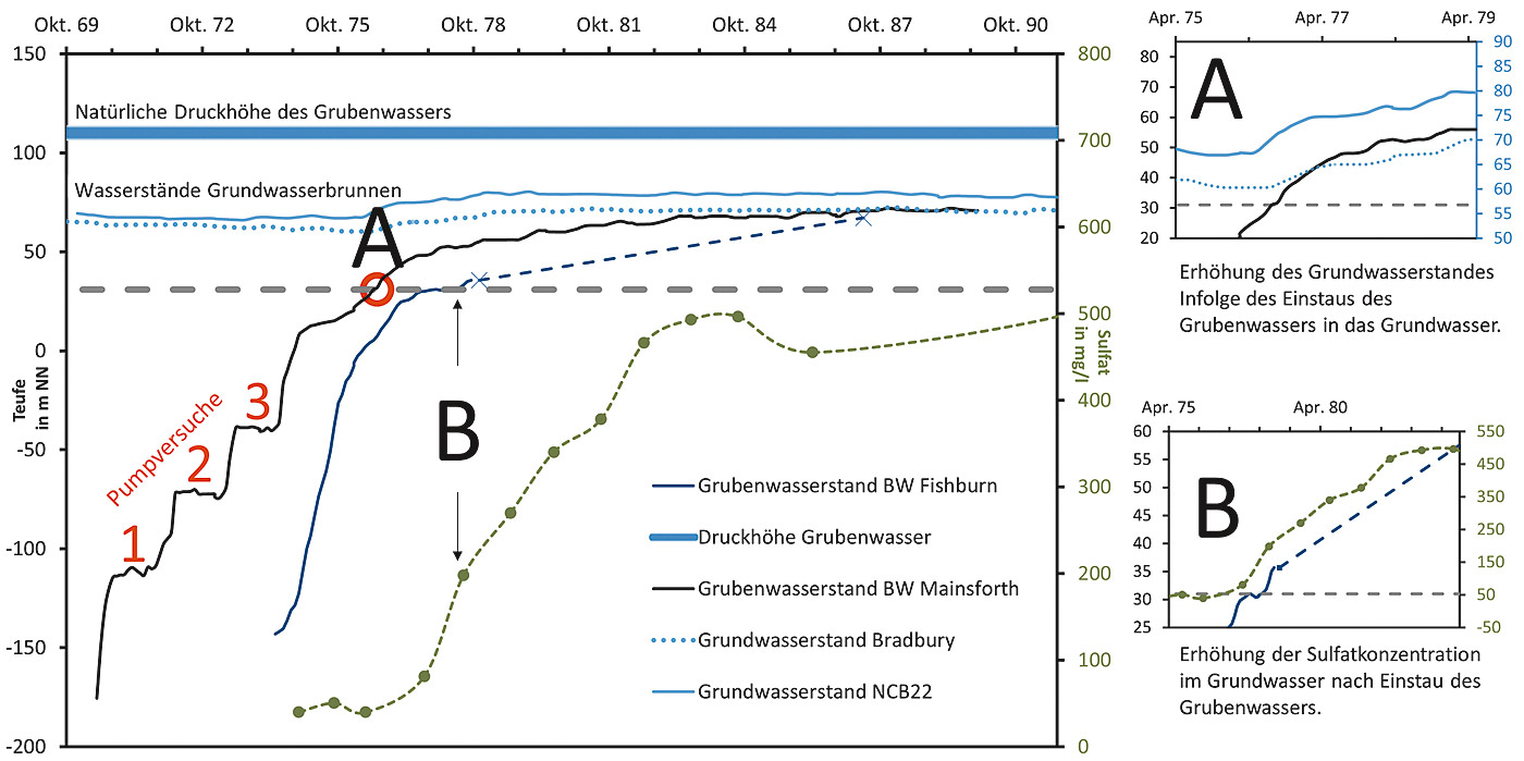
Fig. 3. Increases in mine-water levels at selected collieries and observation points in the Durham coalfield for areas lying south of the Butterknowle fault from 1969 to 1991. The rise in groundwater levels as a result of the increasing height of the mine water is highlighted at inset A. The contamination of the Magnesian Limestone aquifer from the summer of 1976 is reflected in the increases in sulphate concentration levels (green line, inset B). Colliery and borehole water data according to (9, 10, 11). For further explanation see text and Figure 4.
The hydrochemical parameters were monitored at the same time and compared with the set delivery rates. During this operation it became apparent that a steady delivery was more effective than an intermittent discharge, as otherwise there would be a marked decline in water quality (10). These findings indicated that a constant rate of flow should be used for the flooding operation.
Despite this, pumping was halted over the entire area in the mid 1970s, with the result that the mine water was able to rise unimpeded and eventually reached the groundwater aquifer. Crucial to this situation was the fact that the pressure head of the mine water had been wrongly assessed. The deepest workings in this area were in the Brockwell seam, which outcrops just a few kilometres to the west to a height of +125 m OD (above ordnance datum, equivalent to above sea level), where it is fed by precipitation. It therefore potentially has a much greater pressure head – on average about +110 m OD (8) – than the groundwater in the Magnesian Limestone, which in this area exhibits a height of around +90 m OD (7). This situation can also be derived from the mine-water levels of around +105 m OD at the Ladysmith und Woodhouses collieries, which also lie a few kilometres to the west of the area. In 1974 and 1975, driven by these pressure differences, there was a ingress of mine water from Mainsforth colliery into the overlying strata. Over the longer term the mine-water level at Mainsforth initially began to approach the groundwater levels at Bradbury (+72 m OD), a process that continued until the late 1980s, and would remain at this level until about 1993/1994. Over the following ten years there was another slight rise in water level to a point which was just below the groundwater table measured at NCB22 (approximately +80 m OD).
The contamination of the groundwater, which commenced as flooding operations got under way, can be identified from the measured sulphate concentrations at NCB22 (Figure 3). Windlestone colliery, which lies about 2.5 km south west of Mainsforth, had driven a roadway through the Brockwell seam into the overlying strata (Figure 2) and this created a direct hydraulic connection between the collieries and the aquifer (9). Once the mine water at Mainsforth reached the level of this connecting roadway in 1976 (red markings in Figure 3) the groundwater levels at Bradbury and at gauging station NCB22 began to rise by about 10 m. When the mine water at Fishburn colliery also reached the level of this roadway one year later the sulphate concentrations at the observation points at Bradbury and at NCB22 also began to rise fairly quickly, namely from an original level of 30 to 40 mg/l to 200 mg/l in 1978 and then to over 600 mg/l by the mid 1990s. There was no reported increase in iron concentration levels as the net acidic mine water was neutralised by the limestone in the aquifer and the iron was precipitated as a hydroxide deposit on the surface of the cracks and fissures (7).
The rise in groundwater level can be explained by the fact that as the mine water filled up the groundwater was less able to flow down into it as the pressure gradient declined (Figure 3 and Figure 4 middle), and, conversely, when the pressure gradient was reversed it was fed by it (Figure 4 bottom (7, 8, 12)).
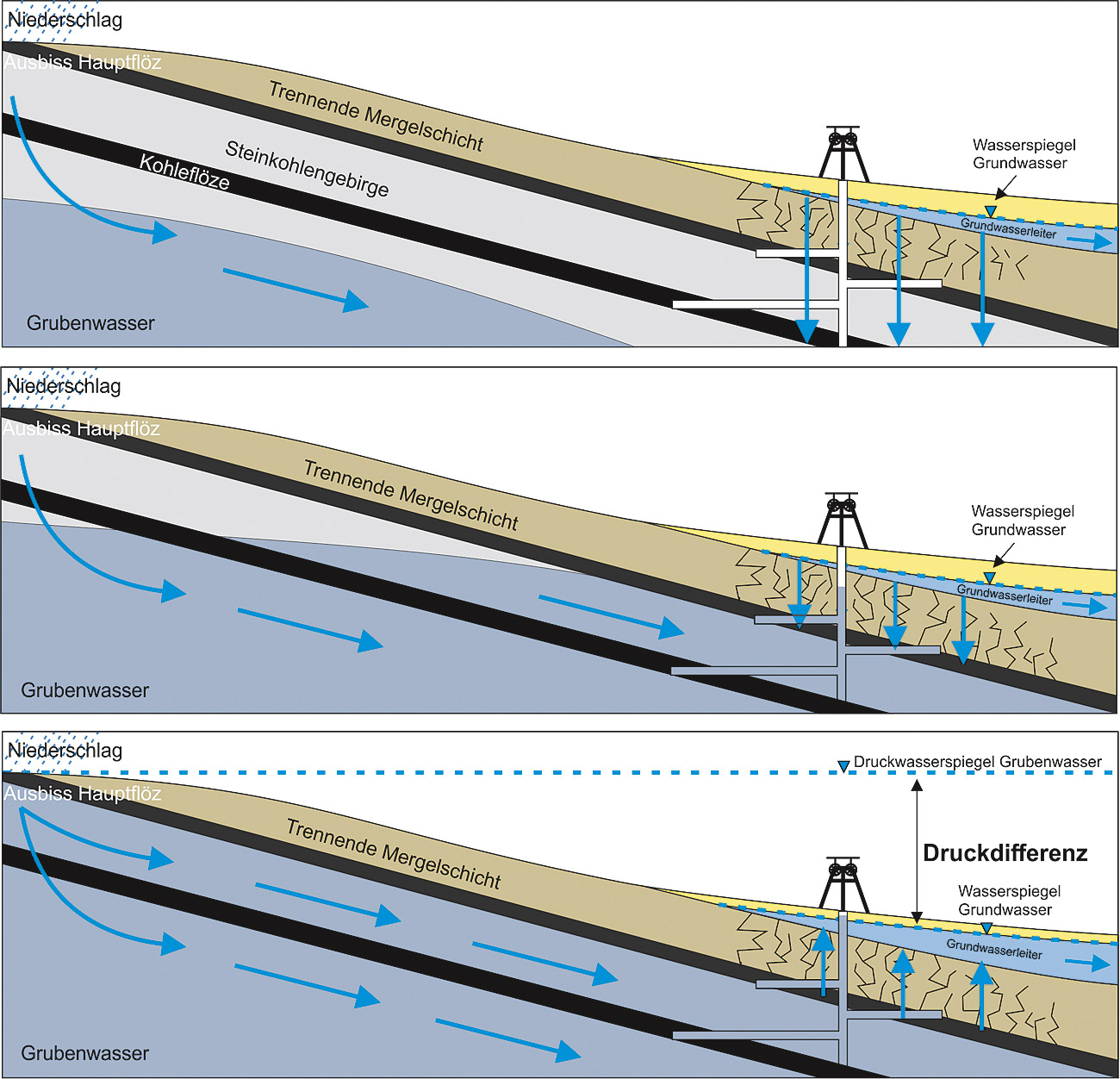
Fig. 4. One possible depiction of the phases in the mine flooding operation during which mine water can infiltrate the groundwater. Top: The groundwater flows into the underlying deposits (pressure-water level of the mine water << water level of the groundwater), there is a reduced flow of the groundwater into the deposits (middle, pressure-water level of the mine water < water level of the groundwater), there is infiltration of the mine water into the groundwater and a resulting increase in the groundwater level (bottom, pressure-water level of the mine water >> water level of the groundwater). Highly schematised and not to scale.
This observation therefore explains the rise in groundwater levels as the mine water floods into the overburden layers. However, it does not account for the fact that both sets of water actually became mixed together, causing an increase in the sulphate concentration level of the groundwater. For this to take place there has to be a potential difference that provides for a direction of flow from the deposits into the aquifer (Figure 4 bottom). The mine-water level therefore has to exhibit a greater hydraulic potential than the groundwater (7). As can be seen from Figure 3 this had not yet happened at the observation points at the time the sulphate concentration levels of the groundwater began to increase. As there was, nevertheless, some mixing of the two bodies of water it therefore has to be assumed that the groundwater level in some areas must have been below the pressure height of the rising mine water, whether for topographic or geogenic reasons, whereby the mine water present in these locations had a potential that enabled it to mix with the groundwater.
In order to examine the evolving chemical parameters of the groundwater a number of models were constructed that took account of various factors such as the spatio-temporal development of the rising mine-water level, the filling of the overlying strata, the chemical composition of the mine water, potential differences in the pressure heights and the manner in which the two bodies of water became mixed (8). One of the findings from this study was that the mixing of the waters can take place not just at selected “hot spots”, e. g. along boreholes, but rather that it is more likely to occur in areas where coal has been extracted right up close to the overlying rock, leading to diffuse transfers of mine water into the groundwater horizon (see above). The aim of the model investigations was to enable temporal and spatial prediction of the spread of the contaminants, as the eastern part of the area contained wells supplying drinking water and the groundwater flow was directed from west to east. Several wells that were used for the recovery of industrial water, and whose usage was not sulphate sensitive, had already been tainted by the sulphate. The first breach of the limit value of 250 mg/l sulphate for the drinking-water wells is likely to occur at the Hope House well in 2019 and then at the Hopper House well in 2024 (Figure 2 (8)).
2.2 East of Wear mining district
A comparable set of problems existed at the group of coal mines lying to the north east of Butterknowle fault. Horden, Easington and Dawdon collieries were situated along the North Sea coast and exhibited similar geological conditions, while Hawthorn mine was only a few kilometres away inland (Figure 1). Here too the Carboniferous beds were overlain with Permian layers some 140 to 180 m thick. From Figure 1 it can be seen that much of the East of Wear mining area is used by the Northumbrian Water company as a source of mains water supply. After dewatering operations ceased in the mid 1990s the water levels in the mines were monitored and on the basis of these observations predictions were drawn up as to when measures would have to be introduced to deal with the impact on the groundwater horizon and/or at the surface (5). For this reason, from about August 2004 steps were taken to keep the mine-water levels in the zone above Horden colliery several metres below the pressure-water level of the joint aquifer (0 to 20 m OD) (Figure 5) and, in addition, the mine water was purified in an active treatment plant.
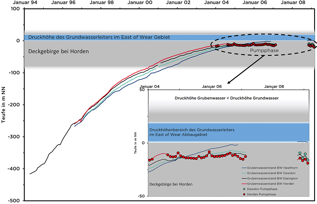
Fig. 5. Progressive rise in mine-water levels at Hawthorn, Dawdon, Easington and Horden collieries in the East of Wear mining area. Mine-water data according to (5, 13). The inset shows how pumping operations undertaken at Dawdon and Horden collieries ensured that the mine-water levels were kept just below the groundwater level in this area, thereby preventing any mixing.
Here the delivery rate was varied between 35 and 150 l/s – equivalent to about 3,000 to 13,000 m3/d or 2.1 to 9 m3/min – in order to investigate the effect of the delivery flow on the water chemistry. It was found that a reduced delivery rate had a positive influence on the iron and chloride concentrations of the mine water (Table 1).
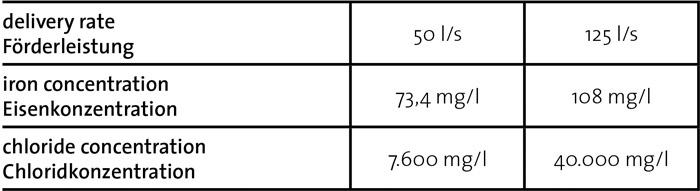
Table 1. Impact of delivery rate on the hydrochemistry at Horden colliery (data acc. to (9)).
From these results it is clear that a high extraction rate promotes the influx of more highly mineralised subterranean waters and hence has a negative impact on the overall mineral content of the intake water and on the formation of a stable density layering.
By allowing the mine water to rise to just a few metres below the level of the groundwater aquifer it was possible to improve the quality of the water being pumped quite considerably. Moreover, pumping costs could be kept to a minimum and sufficient protection provided to prevent the groundwater mixing with the mine water.
In this context the chloride concentration of the mine water in particular is a crucial parameter as the chloride cannot be removed by passive water treatment methods and this rules out the use of plant-based water treatment installations. The area around Horden colliery was originally separated hydraulically from Easington and Dawdon collieries by Ludworth Dyke. The only hydraulic connection was via a mine roadway that according to the records should have been sealed off (5). As Figure 5 shows the measured increases in mine-water levels all exhibit a very similar and practically identical course. This would indicate that there is no stopping between the areas concerned but that in fact an open and hydraulically effective connection can be assumed between the two zones. It is uncertain as to how long this connection can maintain its hydraulic conductibility, as it could break down at any time (5). As the hydraulic pressure gradient in this area is directed from west to east both for the mine water and for the aquifer, in other words towards the coast where the collieries are situated, any hydraulic disruption of this connection would cause the treatment capacity available at Horden (approx. 150 l/s or 13,000 m3/d) to be surpassed and the groundwater would as a result be uncontrollably compromised. In order to prevent such a situation arising an active treatment plant with an identical capacity was also soon installed at Dawdon mine. As the shaft at Dawdon is deeper than that at Horden it was assumed that the water quality would also be worse, e. g., with higher concentrations of chloride and iron. When the water treatment plant was completed at Dawdon towards the end of 2008 it became possible to cut the throughput of the Horden plant back to about 50 l/s. This reduction in pumping performance also resulted in the expected decline in chloride concentration levels, whereby the active plant was dismantled and by 2011 had been replaced by a passive treatment installation covering an area of some 1.7 ha, complete with ventilation system, settling tank and plant-based clarification unit. The treated water is discharged into the nearby North Sea, where even elevated chloride concentration levels have no real impact.
3 France
3.1 Lorraine coalfield
In the Lorraine coalfield on the French side, and at Warndt colliery which is part of the Saar coalfield on the German side, sandstone beds from the Lower Triassic form the regional joint aquifer and provide both industrial water and public mains drinking water. Although the underlying Carboniferous strata – the boundary clays – are classified as being impervious to water, they may be fractured by the mining operations widely practised in the region over the years and as a result will have lost their function as a barrier between the Carboniferous and the Triassic. Coal mining, particularly on the French side of the line, has destroyed the sealing function of the boundary clays in numerous areas (14). Since the year 2000 the drinking-water supply companies in Warndt have been extracting between 10 and 12.6 Mm3 of water a year from this locality (14).
The coal was mined at depths of between 150 m and 1,250 m below sea level, with the associated pumping and dewatering operations also having to extend down to the mining horizons. Fracturing and fissuring of the overlying strata also created large volumes of water that now flowed from the aquifer into the bedrock and the mine workings contained therein, resulting in large cones of depression in the aquifer (15).
The general set of problems associated with the rising mine water is very similar to the situation that has affected the Durham coalfield in the United Kingdom:
- an extensive area of underground coal workings;
- coal mined quite close to the overlying strata;
- shatter zones above the mine workings acting as water pathways between the deposits and the overburden;
- major groundwater horizons in the overlying strata;
- outflow of groundwater into the deposits; and
- threat posed to the aquifer by rising mine water.
During the operational phases of the collieries the water flowing into the deposits from the aquifer was quickly pumped away and hence only had a short dwell time in the deposits zone. It was not therefore enriched with dissolved, problematic substances (16) and could be sold for industrial use, while the surplus water could be safely discharged into the local environment (15). After the mine dewatering measures had ceased such an approach was no longer possible. The much higher dwell times that set in after mine pumping was discontinued led to a significant increase in the mineral content of the water. If this was allowed to rise in an uncontrolled way it could contaminate the aquifer or would have to be pumped out and treated before being discharged, e. g., into a body of receiving water. Another problem that had to be dealt with was that the former mine operators Charbonnages de France (CdF) had left all the mining equipment (machinery, electrical systems and hydraulic installations) in place below ground and this still contained various consumables that posed a risk to the environment (17).
In order to protect the groundwater and also the buildings located in the mining subsidence areas, these structures being situated in some cases below the natural groundwater level, measures were initially put in place to provide for continuous monitoring of the upsurge in mine water that had been taking place since the second half of 2006 (Vouters, Simon 5 and Warndt: June to August 2006; La Houve: December 2006). Figure 6 shows the position of these observation points and the way the coalfield is divided up into a western and a central-eastern area. Warndt colliery is hydraulically separated from the Saar mines further to the east by means of a high-pressure stopping constructed at about the 840 m level (18).
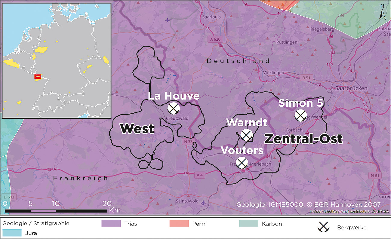
Fig. 6. Overview of the geology and mining districts of the west and central-east Lorraine coalfield, including Warndt colliery. The collieries mentioned in the text (La Houve, Vouters, Warndt and Simon 5) are marked for reference.
3.1.1 Rising mine-water levels at Vouters, Simon 5 and Warndt collieries
Mine dewatering operations were ceased at Vouters, Simon 5 and Warndt collieries between June and August 2006 (17, 19). The rise in the water level in all the mine shafts can be broken down into three phases (Figure 7).
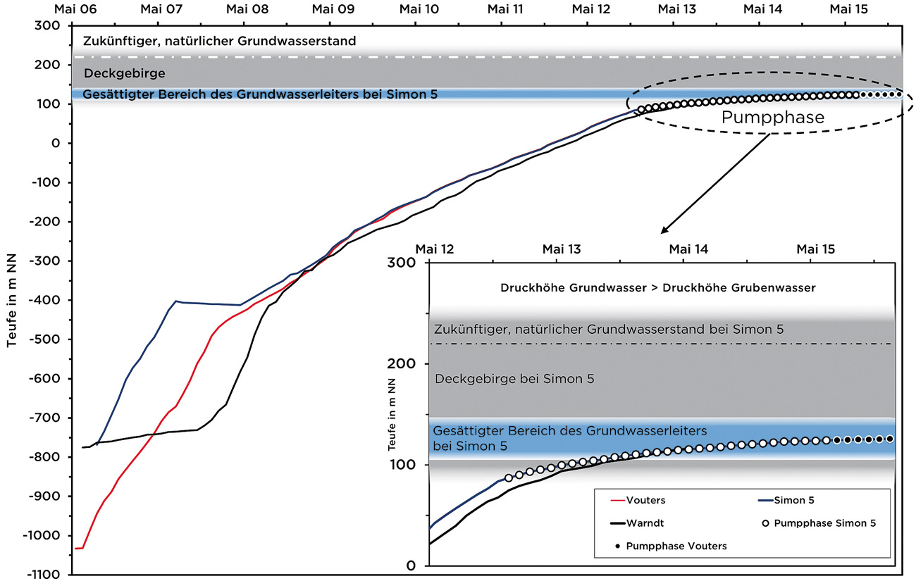
Fig. 7. Rising mine-water levels as measured at the Vouters and Simon 5 observation stations in Lorraine between 2006 and 2015 (data according to (20)) and at Warndt in Germany (data according to (19)). The Permian and Triassic overburden strata are highlighted in colour. The groundwater level in the aquifer at Simon 5 is represented by the blue area while the natural groundwater level is marked by the white broken line above. The inset shows how, during the pumping phase (shown by the line of dots), the pressure level of the mine water was kept just below the groundwater level in order to prevent any mixing of the two.
The first phase was characterised by very high initial rates of increase of as much as 50 m per month, this subsequently reducing fairly quickly over the first year to around 30 m a month. In July 2007 mine-water levels at Simon 5 became static and even declined slightly (the monthly rate of rise fell to somewhere between zero and a slightly negative figure), while at Vouters the rate of increase again reached values of around 42 m a month. Presumably this could be attributed to the presence of a hydraulic connection between the three locations. The water flowed out from the Simon 5 area into the deeper lying and as yet unflooded workings of Vouters und Warndt collieries. The second phase of the mine-water upsurge commenced as the two water levels converged. The mine water at Simon 5 again began to rise, displaying values of around 10 m a month, while the rate of increase at Vouters and Warndt fell back to almost identical levels. The difference between the water levels reduced from the initial figure of up to 270 m in July (Simon 5: 402 m below sea level; Vouters: 670 m below sea level) to around 20 m in April 2008 (Simon 5: 413 m below sea level; Vouters: 433 m below sea level) and then continued to converge during the period 2008 to 2009 until by mid 2009 the groundwater levels at all three sites had assumed almost identical values. The rate of increase then generally varied at between 6 and 11 m a month until the Carboniferous bedrock had become fully saturated, the Permian and Triassic beds of the overlying strata subsequently being completely filled with water by the end of 2012. This marked the start of the third phase of the mine-water ascent, which was marked by the commencement of water pumping operations. These reduced the rate of rise to between 1 and 2 m a month, this subsequently falling even further to practically zero.
3.1.2 Rise in mine water at La Houve colliery
The dewatering measures at La Houve were terminated in December 2006. Here too the rise in water levels can be divided into three phases (Figure 8).
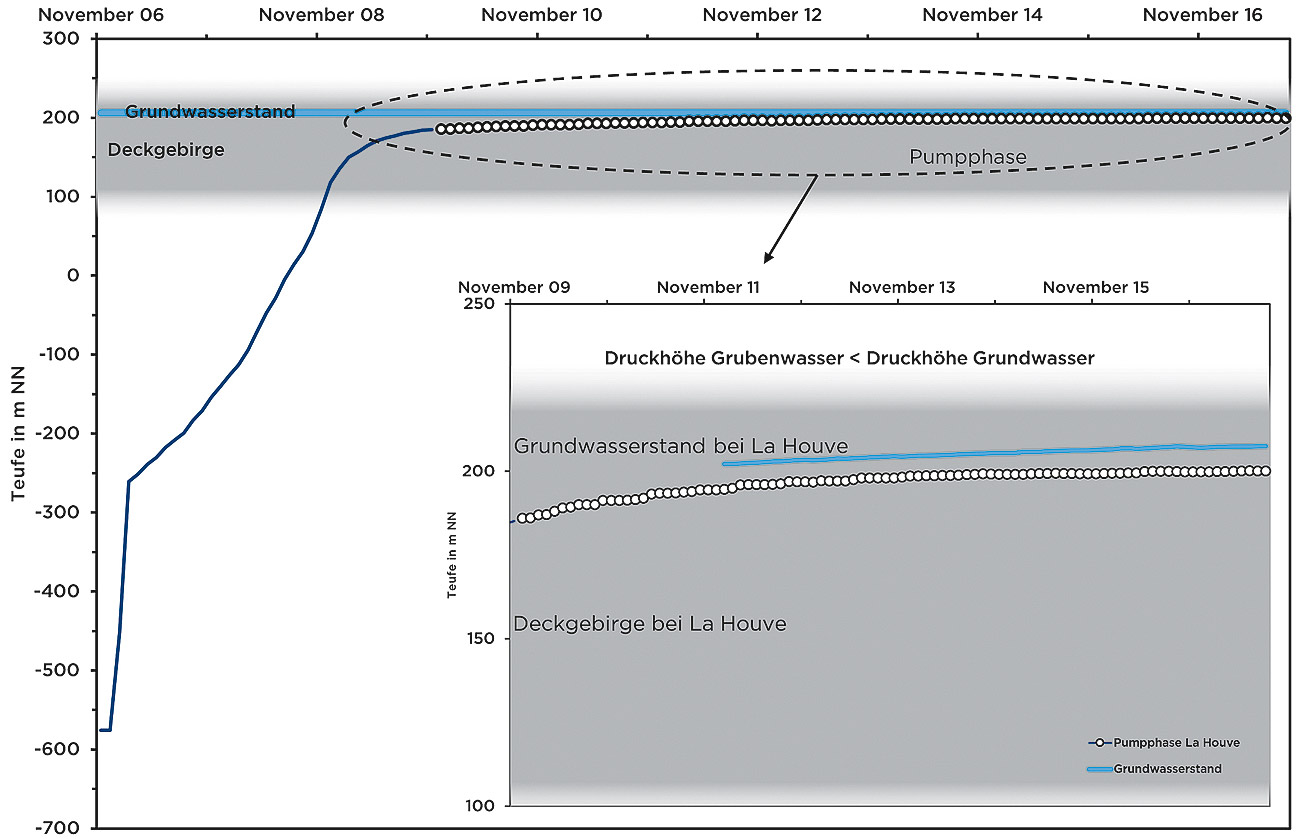
Fig. 8. Rising mine-water levels as measured at the La Houve observation station between 2006 and 2016 (data according to (17)) and at Warndt (data according to (19)). The overburden and current groundwater level are highlighted in colour. The broken line marks the future natural groundwater level. The inset shows in detail how during the pumping phase (represented by the dotted line) the pressure height of the mine water was maintained just below the groundwater level in order to prevent any infiltration of mine water into the aquifer.
The first phase lasted from December 2006 to February 2007 and was marked by exceptionally high rates of increase of as much as 191 m a month. During this period the water rose from about 580 m below sea level to 250 m below sea level. This could be explained by the fact that at these depths the volumetric ratio of the voids was very small in proportion to the reservoir volume (15). As the system entered its second phase the rate of increase dropped off to about 10 m a month. The majority of the coal workings were located at this depth and accordingly the largest floodable cavity volume was also to be found here. At the end of the second phase there was a renewed increase in the rate to between 20 and a maximum of 35 m a month. This was interpreted as the filling of the mining-induced shatter zone above the highest mining horizon. The overlying layers then began to fill with water soon after the local rise reached its maximum of 35 m a month. The rate at which the water rose initially sank to below 10 m a month and then gradually declined to values of around 1 m a month. This can be attributed to two factors: firstly that the inflows continued to decrease in size as the pressure difference declined, and secondly that the aquifer was located in the Triassic sandstones of the overlying strata and in the groundwater-filled zone this did not exhibit a floodable void ratio per se. From November 2009 a resumption of pumping operations succeeded in bringing mine-water levels back down to a point where the rate of rise was dissipating.
3.2 Mine-water management
In order to protect the groundwater horizon La Houve, Vouters and Simon 5 collieries adopted a concept that was similar to that employed in the Durham coalfield, which has been described above. The dewatering measures were resumed at La Houve in November 2009, at Simon 5 in November 2013 and at Vouters in July 2015 and the groundwater was kept several metres below the groundwater pressure height (Figures 7, 8). Maintaining this potential difference, which was generally between 5 and 10 m, and creating a stable density layering effectively prevented any mixing of the two sets of water (15). The groundwater with the higher pressure level can then flow into the mine water, whereas the mine water with the lower pressure level cannot enter the groundwater. The fact that the pressure difference between the two bodies of water is relatively small means that only a small quantity of water can pass from the groundwater horizon into the mine water, as is the case in the Durham coalfield. As a result of this, the groundwater level also gradually rises along with the mine water. However, if the mine water is kept at a constant level then the level of the groundwater will be controlled at the same time and this will prevent any flooding of those areas affected by mining subsidence. Generally speaking, the depth to groundwater should be maintained at 3 m. Nevertheless, in the western part of the coalfield around La Houve colliery some small French towns did experience flooding into the cellars of the houses (21). Here it must also be borne in mind that this represents the natural state of the local wetlands as they were before the mining industry commenced its pumping operations. No uncontrolled gas emissions or damage to infrastructure or environment, including the groundwater, has been identified in the eastern part of the coalfield (22). Some ground uplift of 15 to 20 cm was recorded over a fairly wide area, though this tended to be uniform in nature and so had little or no impact on the local infrastructure.
3.3 Mine-water treatment
Even before mine pumping operations were resumed plans had to be put in place for the provision of mine-water treatment facilities. The empirical data acquired in Britain (23) were used to predict the likely iron and sulphate concentration levels. According to these figures the initial maximum iron concentration of the mine water is in direct correlation with the total sulphur concentration of the deposits and so can be assessed on this basis. After the maximum level has been reached the iron concentration levels slowly begin to fall again. The time required for the iron concentration to fall back to half its original level roughly corresponds to the total mine flooding period. The iron concentration level of the water, as observed long term, will in turn depend on sulphur levels in the coal and on the distance between the water pumping station and the area where the deposits outcrop at ground level. This is because the outcrop zones are significant sources of pyrite oxidation.
The first of three mine-water treatment plants (La Houve) was built on the basis of these assumptions. This installation has been designed as a passive treatment facility with an aeration cascade, a 1,800 m2 settling tank and three adjoining plant-based clarification units with a total surface area of 3,400 m2 (15). While the modelled concentration progression for iron was incorrect and the actual values showed a significant delay in the reduction of the iron concentration levels, nevertheless the system was able to demonstrate a high degree of operational reliability. The initial iron-concentration levels were in a similar order of magnitude to the modelled values, which meant that the purification performance of the plant was not exceeded. However, the delayed reduction in concentration levels has led to a significant increase in sludge residues in the settling tanks since the plant was commissioned and this ultimately resulted in higher expenditure on maintenance and hence in increased operating costs too. Nevertheless, in overall terms the plant always managed to filter out more than 94 % of the dissolved iron, with a peak performance of as much as 99 %, and was able to maintain the prescribed maximum iron concentration levels of 2 mg/l in the mine water being released into the environment. One possible reason for the discrepancy between the predicted and the actual values is that the pump output was not constant but in fact varied considerably. When the pump is operating at a high but steady rate of delivery there is indeed a marked downturn in the iron levels, whereas during those phases when there is a variable delivery rate the iron values have a wide spread and tend to increase (17).
Two further passive treatment plants were built in addition to the one at La Houve. These were the Simon facility, which was set up in November 2012 to treat mine water from the central and eastern part of the coalfield, and the Vouters plant, which has a maximum capacity of around 12,000 m3/d (approx. 8.3 m3/min) and was built in July 2015 in order to process mine water from the same area. Both facilities have a similar performance to the first plant at La Houve but have to deal with higher zinc and copper levels in the intake water (17).
4 Summary
The experience acquired in the UK and France shows that a sustainable mine-water management regime can be developed by having an understanding of the regional hydrogeological relationships and by applying fundamental hydraulic principles. The protection of the drinking water in both the Durham and Lorraine coalfields is now assured by maintaining a comparatively small potential difference of just a few metres between the groundwater and the mine water. In both locations the increase in mine-water levels has also resulted in a rise in the groundwater level and when the topographical conditions are right this can lead to areas of standing water and the creation of polder wetlands. An extensive monitoring programme and the provision of appropriate pumping systems are therefore required. After it has been raised to the surface the water can be treated using either an active or a passive process (or a combination of both), depending on its chemical composition and rate of production, and can then be discharged into the receiving waters provided it meets the given limit values.
References
References
(1) Goerke-Mallet, P.; Reker, B.; Westermann, S.; Melchers, C. (2017): Nachbergbau in Großbritannien: das Steinkohlenrevier South Yorkshire. In: Markscheidewesen 124 (1), S. 13 – 21.
(2) Reker, B.; Goerke-Mallet, P.; Westermann, S.; Melchers, C. (2018): Die britische Steinkohle und der Nachbergbau: Eindrücke aus dem Revier South Yorkshire und aktuelle Entwicklungen in Großbritannien. In: Bergbau 69 (6), S. 269 – 275.
(3) Hill, A. (2012): Coal, a chronology for Great Britain; The Northern Mine Research Society, British Mining No. 94, 272 S., 69 Abb. ISBN 978 0 901450 68 5.
(4) Younger, P. L. (1995): Hydrogeology. Chapter 11. In: Johnson, G. A. L.: Robson’s Geology of North East England. (The Geology of North East England, Second Edition). – Transactions of the Natural History Society of Northumbria, Vol. 56, (5); S. 353 – 359.
(5) Watson, I. (2011): Managing rising mine water to prevent aquifer pollution. Präsentation im Rhamen der Konferenz “Contaminated Ground, Contaminated Groundwater?” des UK Groundwater Forum am 24.05.2011 in London.
(6) Bearcock, J.; Smedley, P. L. (2009): Baseline Groundwater Chemistry: the Magnesian Limestone of County Durham and North Yorkshire. British Geological Survey Open Report OR/09/030.
(7) Younger, P. L.; Adams, R. (1999): Predicting Mine Water Rebound. Environment Agency, R&D Technical Report, W179.
(8) Neymeyer, A.; Williams, R. T.; Younger, P. L. (2007): Migration of polluted mine water in a public supply aquifer. In: Quarterly Journal of Engineering Geology and Hydrogeology, 40, S. 75 – 84.
(9) Pastor, J.; Klinger, C.; Talbot, C.; Whitworth, K.; Suso Llamas, J. M. (2008): Optimisation of mine water discharge by monitoring and modelling of geochemical processes and development of measures to protect aquifers and active mining areas from mine water contamination. Final report. Luxembourg, Luxembourg: Off. For Official Publ. of the European Communities (EUR Research Fund for Coal and Steel series, 23456).
(10) Cairney, T.; Frost, R. C. (1975): A case study of mine water quality deterioration, Mainsorth colliery, County Durham. In: Journal of Hydrology, 25, S. 275 – 293.
(11) Kortas, L.; Younger, P. L. (2007): Using the GRAM Model to Reconstruct the Important Factors in Historic Groundwater Rebound in Part of the Durham Coalfield, UK. In: Mine Water and the Environment 26 (2), S. 60 – 69.
(12) Younger, P. L. (1993): Possible environmental impact of the closure of two collieries in County Durham. In: Jl. Inst. Water and Environmental Management, 7 (5), S. 521 – 531.
(13) Whitworth, K. R. (2002): The monitoring and modelling of mine water recovery in UK coalfields. In: Younger, P. L. & Robins, N. S. (2002): Mine Water Hydrogeology and Geochemistry. Geological Society, London, Special Publications, 198, S. 61 – 73.
(14) Wagner, J. (2010): Zukunft Warndt Wasser – Handlungsstudie zu den Chancen nach dem Anstieg des Grundwassers im Warndt. Unveröffentlichte Studie der Fa. Grundwasser- und Geo-Forschung Neunkirchen.
(15) Koeberlé, N.; Levicki, R.; Kaiser, J.; Heitz, S. (2013): Treating mine waters in the Lorraine coal field – feedback from the La Houve treatment plant. In: Tibbett, M.; Fourie, A. B. & Digby, C. (eds): Proceedings of the Eighth International Conference on Mine Closure, 18. – 20. September 2013, Cornwall, United Kingdom. Australian Centre for Geomechanics, S. 171 – 182, 2013.
(16) Blachere, A.; Lefort, D. (2003): Etude prévisionnelle de la qualité des eaux après remplissage des mines des secteurs Est, Ouest et Centre. Bureau d’études Cesame.
(17) Corbel, S.; Kaiser, J.; Vicentin, S. (2017): Coal mine flooding in the Lorraine-Saar basin: experience from the French mines. In: Wolkersdorfer, C.; Sartz, L.; Sillanpää, M.; Häkkinen, A. (eds): IMWA 2017 – Mine Water & Circular Economy. Lappeenranta, Finland 2017, S. 161 – 166.
(18) RAG (2015): Grubenwasser in der Diskussion. Broschüre der RAG Aktiengesellschaft. Online verfügbar unter: www.bergbau-unser-erbe.de/fileadmin/user_upload/Grubenwasser_in_der_Diskussion.pdf (Stand: 31.01.2019).
(19) Schäfer, A. (2016): Das Grubenwasser im saarländischen Steinkohlerevier nach dem Ende der Gewinnung. In: Bergbau 67 (4), S. 172 – 176.
(20) Cosquer, R. (2016): Compte-rendu d’activités DPSM – Année 2015/Lorraine. Rapport final, BRGM/RP-65651-FR.
(21) Ernst, N.; Maillasson, H. (2018): In Lothringen sind die Gruben längst geflutet. Onlineartikel der Saarbrücker Zeitung vom 31. Juli 2018. Online verfügbar unter: www.saarbruecker-zeitung.de/saarland/blickzumnachbarn/frankreich/in-lothringen-sind-die-gruben-laengst-geflutet_aid-24159007 (Stand 31.01.2019).
(22) Schleuning, J. (2018): Welche Auswirkungen die aktuelle Grubenflutung im Saarland hat. Onlineartikel der Saarbrücker Zeitung vom 28. Januar 2019. Online verfügbar unter:
www.saarbruecker-zeitung.de/saarland/saarland/welche-auswirkungen-die-aktuelle-grubenflutung-im-warndt-hat_aid-35960693 (Stand: 31.01.2019).
(23) Younger, P. L. (2000): Predicting temporal changes in total iron concentrations in groundwaters flowing from abandoned deep mines: a first approximation. In: Journal of Contaminant Hydrology, 44(1), S. 47 – 69.